the Nile River
The longest river in the world is located in Africa and flows to the north. It has two main tributaries, the White Nile and the Blue Nile. The White Nile originates in the Great Lakes region in Central Africa. The most distant source is in southern Rwanda at coordinates 2°16′55.92″S 29°19′52.32″E
It flows from northern Tanzania to Lake Victoria, to Uganda and then South Sudan, while the Blue Nile begins in Lake Tana in Ethiopia at coordinates 12°2′8.8″N 37°15′53.11″E
Then it flows to Sudan from the southeast, then the two rivers meet at the Sudanese capital, Khartoum.
The total length of the river is 6650 km (4132) miles, and the Nile Basin covers an area of 3.4 million km².
Its path passes through ten African countries called the Nile Basin countries.
its path The Nile River meets in the capital of Sudan, Khartoum, and consists of two main tributaries that feed it: the White Nile from the Lakes Plateau (Lake Victoria), and the “Blue Nile” from Ethiopia, Lake Tana (Lake Tana). Further south, it is a tributary of the Kagera River that cuts a 690 km (429 mi) course before emptying into Lake Victoria. Lake Victoria is the main source of water for the White Nile and is the second largest freshwater lake in the world. This lake is located in an area rich in swamps on the borders of Uganda, Tanzania and Kenya and crossed by the equator, and this lake in turn is considered the third great lake. It has an area of 67,000 square kilometers and an average depth of 40 meters.
The Nile comes out of Lake Victoria at the city of Jinja. The Nile in this part is known as the Victoria Nile and runs for a distance of 70 kilometers until it enters Lake Kyoga, a shallow lake not exceeding 77 meters in depth, then leaves it at the port of Masindi and continues its path through Morchanson Falls for a distance of 500km (300 mi) until it reaches Lake Albert after 5,000 km (300 mi) after leaving Lake Victoria, descending about 514 m. Lake Albert covers an area of about 5,300 square kilometers and is fed by the Smiliki River, which originates from Lake Edward.
After leaving Lake Albert, the Nile is known as the Nile Albert, then the Nile reaches the Republic of South Sudan to enter it at the city of Nimoli, where it passes through the Falls of Fula to be known then as the Sea of the Mountain, and then meets the Aswa River, 20 km from Nimoli. The river then enters the dams area, which is an area of dense swamps, and the Giraffe Sea branches from it to meet with it later. Then the river connects with Bahr al-Ghazal and flows eastward to meet with the Sea of Giraffes, then it meets with the Sobat River, which originates from the Abyssinian plateau. Then it regains its course towards the north, and the Nile extends for a distance of 720 km (445 miles) in which it is known as the White Nile, and the Nile continues on its path bearing this name until it enters the Republic of Sudan .Then it passes through the Sudanese capital, Khartoum
The Blue Nile comes with (80-85%) of the water feeding the Nile, but this water reaches it only in the summer During the monsoon rains fall on the Abyssinia plateau, which is known as the Nile flood, while it does not form on the rest of the days From the year the same percentage where the water is less
The Blue Nile originates from Lake Tana, located in the highlands of Ethiopia in eastern Africa, and is fed by only 7% of its revenue.
On average, it is fed by a number of tributaries with the remainder.
It meets the rivers Rahad and Dinder inside Sudanese territory.
It is called Abay in Amharic, while it is called the "Blue Nile" after crossing the Ethiopian-Sudanese border.
This Nile, bearing its Sudanese name, continues on a 1,400-kilometre (850-mile) path until it meets the other branch - the “White Nile” - at Muqrin in Khartoum to form together from that point, passing through the territory of Egypt, and even downstream in the Mediterranean, what is known as the Nile
Nile confluence
After the union of the White and Blue Niles at Muqrin Khartoum to form the Nile River, there is only one tributary left for the Nile to feed it with water before entering Egypt, the Atbara River, which has a length of approximately 800 km (500 miles).
This river also originates in the Ethiopian highlands, north of Lake Tana, and connects to the Nile at a distance of 300 km (200 miles) after the city of Khartoum
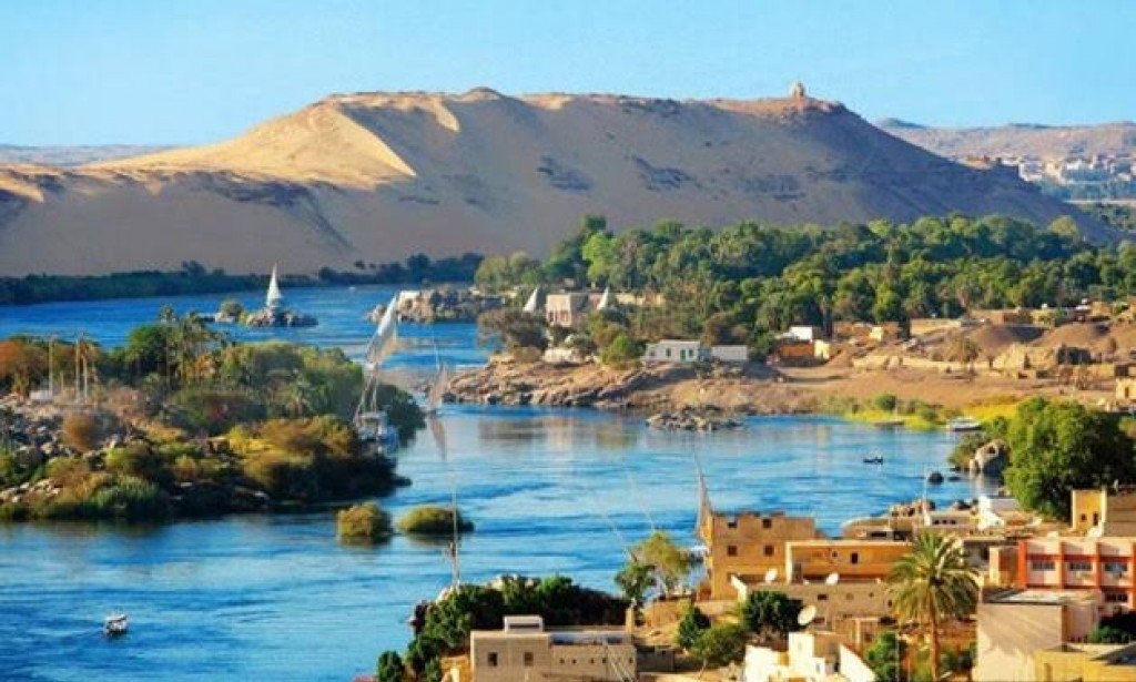
In the north of Khartoum, the Nile passes through six waterfalls;
The Sixth Waterfall in Al-Salouqa (North of Khartoum) to the Aswan Waterfall - in Egypt.
And it changes its course, as the course of the Nile bends in a southwesterly direction near the city of Abu Hamad, before returning to its original path - north - near the city of Al-Dibbah, and this curved part is called “the great bend of the Nile.”
After returning to its original course, the Nile crosses the Sudanese-Egyptian border, and continues its course inside Egypt until it reaches Lake Nasser: - an artificial lake located behind the High Dam.
Starting in 1998, some parts of this lake separated in the west into the Western Desert to form Toshka Lakes
Returning to its original course in Lake Nasser, the Nile leaves the lake and heads north until it reaches the Mediterranean. Along this path, a part of the river branches off at Assiut, called Bahr Youssef, and continues until it reaches Fayoum. The Nile River reaches the far north of Egypt, to split into two branches: the Damietta branch in the east and the Rashid branch in the west, and they confine between them the Nile Delta, which is considered at the top of the list of deltas in the world, and the Nile eventually flows through these two branches in the Mediterranean Sea, ending its long path from central East Africa and even north. Among the cities that the Nile passes through after the confluence are Shendi, Al Matma, Al-Damir, Atbara and Abu Hamad, ending with Halfa before entering Egypt

يجب عليك تسجيل الدخول لتستطيع كتابة تعليق